Alto Caparaó
Digital Passport
Nomenclature and Geography
Category: City / Municipality
Summary
About the place: Alto Caparaó is a Brazilian municipality located in the state of Minas Gerais in the Southeast region of the country. It is widely known as a gateway to the Caparaó National Park, home to Brazil's third-highest peak, Pico da Bandeira.
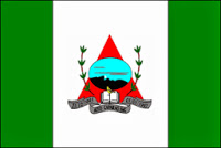
Flag Description: The flag consists of three vertical stripes of green, wide white, and green. In the center of the broader white stripe is the municipal coat of arms. Its dominant feature is a red isosceles triangle overlaid with a circular/oval medallion depicting a sky-blue backdrop with a dark mountain range outline. At the base of the triangle lies an open book with a butterfly, flanked by two green coffee branches. Below the emblem is a grey ribbon inscribed with '27-04-1992 ALTO CAPARAÓ-MG 01-01-1993'.
Symbolism: The red triangle references the flag of Minas Gerais, symbolizing freedom. The mountain silhouette represents the Caparaó National Park and the Pico da Bandeira range. The coffee branches represent coffee cultivation as the main agricultural backbone of the municipality. The open book symbolizes education and knowledge, while the dates on the ribbon mark the creation and official establishment of the municipality in 1992–1993.
Statistics
Area
104.57 km²
Population
5,795