Araruama
Digital Passport
Nomenclature and Geography
Category: City / Municipality
Summary
About the place: Araruama is a municipality located in the Região dos Lagos region of the state of Rio de Janeiro, Brazil. It is widely known for its vast saltwater lagoon and popular coastal tourism.
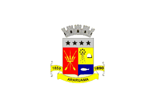
Flag Description: The flag consists of a white field with the municipal coat of arms centered. The shield is surmounted by a silver mural crown and features a silver chief with four black five-pointed stars. The main shield is party per pale, with the dexter field in red depicting crossed paddles and indigenous gear, while the sinister field is divided horizontally into a yellow upper section containing a windmill and a salt mound, and a blue lower section displaying a white fish. Below the shield is a yellow scroll inscribed with 'ARARUAMA' and flanked by the dates '1859' on the left and '1890' on the right.
Symbolism: The white color represents peace. The coat of arms reflects the history and economy of the municipality: the stars represent its districts, the crossed paddles honor the indigenous heritage, the windmill and salt pile represent traditional salt production from the lagoon, and the fish stands for local fishing. The dates 1859 and 1890 mark historical milestones in the political creation and emancipation of the municipality.
Statistics
Area
638.15 km²
Population
134,358