Atalaia do Norte
Digital Passport
Nomenclature and Geography
Category: City / Municipality
Summary
About the place: Atalaia do Norte is the westernmost municipality in the Brazilian state of Amazonas, located directly on the border with Peru. It is widely known as the gateway to the Vale do Javari Indigenous Territory, home to one of the world's highest concentrations of uncontacted indigenous tribes.
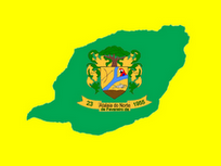
Flag Description: The flag consists of a yellow field centered with a large green silhouette depicting the geographical map outline of the municipality. Placed in the middle of this green shape is the municipal coat of arms featuring a green tree above the shield and golden mantling. The shield is divided by a blue pall representing river confluence, with crossed tools in the upper left section from the viewer's perspective, a macaw head in the upper right section, and a fish above brown soil in the lower section. Below the shield is a golden ribbon with the black inscription '23 de Fevereiro de 1955' and the municipality's name 'Atalaia do Norte'.
Symbolism: The yellow field symbolizes the region's richness and sunshine, while the green silhouette represents the vast rainforests and the actual geographical map contour of the municipality. The central coat of arms highlights local natural elements: the tree represents the Amazon forest, the blue river branch symbolizes local waterways (Javari River), the macaw and fish illustrate rich wildlife, and the date on the scroll (February 23, 1955) commemorates the official creation of the municipality.
Statistics
Area
60,628.50 km²
Population
15,314