Attert
Digital Passport
Nomenclature and Geography
Category: City / Municipality
Summary
About the place: Attert is a municipality located in the Belgian province of Luxembourg, within the Walloon Region. It lies along the river Attert near the border with the Grand Duchy of Luxembourg.
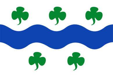
Flag Description: The flag features a white field horizontally divided by a wavy blue stripe across the middle. Accompanied in the upper white portion are three green trefoils arranged side by side, and in the lower white portion are two green trefoils.
Symbolism: The wavy blue stripe represents the river Attert, which flows through the municipality and gives it its name. The five green trefoils represent the five former municipalities (Attert, Nobressart, Nothomb, Thiaumont, and Tontelange) that merged to form the present-day municipality.
Statistics
Area
89.40 km²
Population
5,620