Bonfim, Roraima
Digital Passport
Nomenclature and Geography
Category: City / Municipality
Summary
About the place: Bonfim is a municipality located in the eastern part of the state of Roraima, Brazil, on the border with Guyana. Positioned near the Tacutu River, it serves as an important border crossing and trade hub for the region.
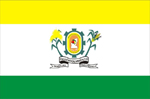
Flag Description: The flag consists of three horizontal bands: a yellow top band, a broader white central band, and a green bottom band. In the center of the white band rests the coat of arms of Bonfim, featuring a cogwheel surrounding an oval shield, flanked by agricultural crops and supported by scrolls with inscriptions at the bottom.
Symbolism: Yellow represents wealth and sunshine, white signifies peace and purity, and green symbolizes the lush forests and nature of Roraima. The coat of arms in the center highlights industrial development via the cogwheel, agriculture through the side crops, and local community identity.
Statistics
Area
8,095.42 km²
Population
12,548