Březová (Uherské Hradiště District)
Digital Passport
Nomenclature and Geography
Category: City / Municipality
Summary
About the place: Březová is a municipality located in the southeastern part of Uherské Hradiště District in the Zlín Region of the Czech Republic, situated in the White Carpathians Protected Landscape Area along the Slovak border. The village stretches along the Hrubár stream at the foot of Mount Velký Lopeník within the traditional Moravian Kopanice region.
Flag Description: Březová is a Moravian border municipality located in the southeastern part of Uherské Hradiště District in the Zlín Region of the Czech Republic, set in a scenic valley of the White Carpathians near the Czech–Slovak border beneath Velký Lopeník mountain. The village is traversed by the Hrubár stream and is characterized by a traditional sub-mountainous landscape of the Moravian Kopanice cultural area.
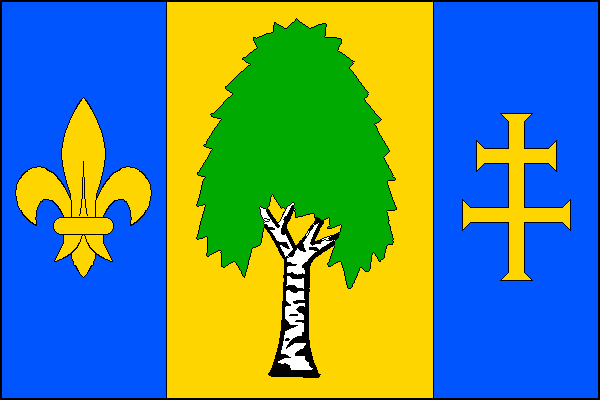
Symbolism: The municipal symbols were designed by heraldist Miroslav Paulů and officially granted on 22 November 2001 (Decision No. 97). The birch tree in the central pale is a canting charge referencing the municipality's name (derived from the Czech 'bříza' meaning birch, historically present on the municipal seal of 1702) and the local abundance of birch groves. The golden/yellow fleur-de-lis in the hoist stripe symbolizes the Virgin Mary and the dedication of the historic church of St. John the Baptist and the Virgin Mary (1747–1749). The golden/yellow patriarchal cross in the fly stripe represents Saints Cyril and Methodius, to whom the present parish church (built in 1865) is dedicated. The blue tincture evokes the valley's local streams (Hrubár and Zlatný potok) as well as Marian symbolism.
Flag Description: Březová is a Moravian border municipality located in the southeastern part of Uherské Hradiště District in the Zlín Region of the Czech Republic, set in a scenic valley of the White Carpathians near the Czech–Slovak border beneath Velký Lopeník mountain. The village is traversed by the Hrubár stream and is characterized by a traditional sub-mountainous landscape of the Moravian Kopanice cultural area.
Symbolism: The municipal symbols were designed by heraldist Miroslav Paulů and officially granted on 22 November 2001 (Decision No. 97). The birch tree in the central pale is a canting charge referencing the municipality's name (derived from the Czech 'bříza' meaning birch, historically present on the municipal seal of 1702) and the local abundance of birch groves. The golden/yellow fleur-de-lis in the hoist stripe symbolizes the Virgin Mary and the dedication of the historic church of St. John the Baptist and the Virgin Mary (1747–1749). The golden/yellow patriarchal cross in the fly stripe represents Saints Cyril and Methodius, to whom the present parish church (built in 1865) is dedicated. The blue tincture evokes the valley's local streams (Hrubár and Zlatný potok) as well as Marian symbolism.
Statistics
Area
13.74 km²
Population
966