Bujesily
Digital Passport
Nomenclature and Geography
Category: City / Municipality
Summary
About the place: Bujesily is a small rural municipality in the Rokycany District of the Plzeň Region, located on a plateau above the Berounka River valley roughly 15 km north of Rokycany. It has a population of around 85 inhabitants and features a peaceful agricultural and recreational character.
Flag Description: Bujesily is a small rural municipality in the northern part of the Rokycany District in the Plzeň Region, situated on an elevated plateau above the deeply incised valley of the Berounka River in a scenic forested landscape of western Bohemia.
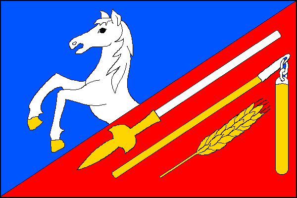
Symbolism: The rearing horse serves as a canting symbol referencing the folk etymology of the village's name ("bujné síly" – rampant strength, vitality, and power). The golden partisan represents defense and local historical military events. The flail and ear of grain symbolize the traditional agricultural heritage of the village, hard rural labor, and the fertility of the land. The blue color alludes to the nearby Berounka River.
Flag Description: Bujesily is a small rural municipality in the northern part of the Rokycany District in the Plzeň Region, situated on an elevated plateau above the deeply incised valley of the Berounka River in a scenic forested landscape of western Bohemia.
Symbolism: The rearing horse serves as a canting symbol referencing the folk etymology of the village's name ("bujné síly" – rampant strength, vitality, and power). The golden partisan represents defense and local historical military events. The flail and ear of grain symbolize the traditional agricultural heritage of the village, hard rural labor, and the fertility of the land. The blue color alludes to the nearby Berounka River.
Statistics
Area
6.20 km²
Population
85