Buk (Přerov District)
Digital Passport
Nomenclature and Geography
Category: City / Municipality
Summary
About the place: Buk is a Moravian municipality and village located in the Olomouc Region (Přerov District), about 6 km north of Přerov in the gently undulating agricultural landscape of the Tršice Hilly Land. It is a quiet rural community with historical roots dating back to the 13th century.
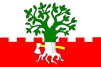
Flag Description: The flag consists of two horizontal stripes, white and embattled red, in a width ratio of 11:9. The red stripe has four rectangular merlons and three equal embrasures. In the center of the sheet is an eradicated beech tree, green in the white stripe and white in the red stripe. In the red stripe, the trunk is debruised by a horizontal white axe with a yellow haft pointing toward the fly and the blade pointing up. The width-to-length ratio is 2:3.
Symbolism: The eradicated beech tree is canting arms referring to the village name (Buk means 'beech' in Czech). The embattled line of the red stripe commemorates the lost medieval stronghold (fortress) that stood in the village during the 14th and 15th centuries. The axe represents forest clearing, historic forestry, and the founding of the settlement in wooded lands, while the red and white tincture draws on regional Moravian heraldic traditions.
Flag Description: The flag consists of two horizontal stripes, white and embattled red, in a width ratio of 11:9. The red stripe has four rectangular merlons and three equal embrasures. In the center of the sheet is an eradicated beech tree, green in the white stripe and white in the red stripe. In the red stripe, the trunk is debruised by a horizontal white axe with a yellow haft pointing toward the fly and the blade pointing up. The width-to-length ratio is 2:3.
Symbolism: The eradicated beech tree is canting arms referring to the village name (Buk means 'beech' in Czech). The embattled line of the red stripe commemorates the lost medieval stronghold (fortress) that stood in the village during the 14th and 15th centuries. The axe represents forest clearing, historic forestry, and the founding of the settlement in wooded lands, while the red and white tincture draws on regional Moravian heraldic traditions.
Statistics
Area
3.78 km²
Population
380