Bukovany (Hodonín District)
Digital Passport
Nomenclature and Geography
Category: City / Municipality
Summary
About the place: Bukovany is a municipality in the Hodonín District of the South Moravian Region, situated in the rolling hills of the Kyjov Hills (Kyjovská pahorkatina) about 4 km northwest of Kyjov. It is a traditional agricultural and winemaking village, notable also for the local Bukovanský mlýn observation windmill.
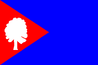
Flag Description: A blue field with a red hoist triangle extending to the center of the flag. Inside the triangle is a truncated (couped) white beech tree. The aspect ratio is 2:3.
Symbolism: The white beech tree serves as a canting symbol directly alluding to the municipality's name (Bukovany, from 'buk' meaning beech). The red and blue colors are derived from the municipal coat of arms, where the red base features vinicultural implements representing the local winemaking and agrarian tradition.
Flag Description: A blue field with a red hoist triangle extending to the center of the flag. Inside the triangle is a truncated (couped) white beech tree. The aspect ratio is 2:3.
Symbolism: The white beech tree serves as a canting symbol directly alluding to the municipality's name (Bukovany, from 'buk' meaning beech). The red and blue colors are derived from the municipal coat of arms, where the red base features vinicultural implements representing the local winemaking and agrarian tradition.
Statistics
Area
3.29 km²
Population
691