Cametá
Digital Passport
Nomenclature and Geography
Category: City / Municipality
Summary
About the place: Cametá is a Brazilian municipality and port city in the state of Pará, located on the left bank of the Tocantins River. The city boasts a rich colonial history and serves as an important regional hub for agriculture and fishing.
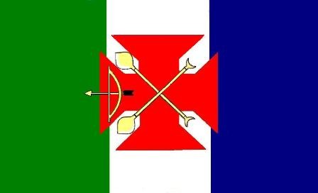
Flag Description: The flag consists of three vertical bands of blue, white, and green. In the center of the white band is a red cross pattée. Superimposed over the cross are two crossed oars (or paddles) with yellow blades and notched handles. To the right of the center (from the viewer's perspective) is a horizontally placed drawn bow with an arrow pointing to the right.
Symbolism: The blue, white, and green stripes represent the water resources (the Tocantins River), peace, and the lush Amazonian nature. The red cross pattée symbolizes the Christian faith and the historical influence of Portuguese missions. The crossed oars and bow with arrow commemorate the traditional riverine lifestyle and the indigenous heritage of the region.
Statistics
Area
3,081.00 km²
Population
140,800