Carapicuíba
Digital Passport
Nomenclature and Geography
Category: City / Municipality
Summary
About the place: Carapicuíba is a Brazilian municipality located in the metropolitan area of São Paulo, in the state of São Paulo. It is one of the most densely populated municipalities in Brazil.
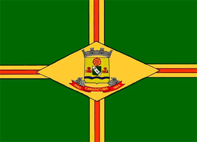
Flag Description: The flag consists of a green field with a centered Saint George's cross composed of a central red stripe bordered by two thin yellow stripes. In the center of the flag is a yellow lozenge containing the municipal coat of arms. The coat of arms features a yellow shield topped with a wall crown and supported below by a red ribbon bearing the text 'CARAPICUÍBA' alongside the dates '1580' and '1965'. The shield contains a red cogwheel near the top, a green bend, initials, and wavy blue lines at the bottom.
Symbolism: The green field represents Brazilian nature and hope, while the Saint George's cross and yellow lozenge mirror traditional Brazilian vexillological motifs and national colors. The red color symbolizes courage and determination. The coat of arms marks the founding of the settlement in 1580, municipality status achieved in 1965, and industrial development symbolized by cogwheels.
Statistics
Area
34.97 km²
Population
403,183