Caroebe
Digital Passport
Nomenclature and Geography
Category: City / Municipality
Summary
About the place: Caroebe is a municipality located in the southeastern part of the state of Roraima, Brazil. It is particularly known for its agricultural importance, especially banana production.
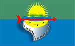
Flag Description: The flag consists of a horizontal bicolour of green and blue. Centered is an emblem featuring a radiant yellow sun with green vegetation at its base, below which sits a blue canoe, a cluster of yellow bananas, and a silver-grey shield-like element inscribed with 'CAROEBE 4 NOVEMBRO 1994' in black text. A horizontal red arrow pointing to the right (viewer's right) lays across the center of the emblem.
Symbolism: The green stripe and vegetation represent lush forests and agriculture, while the blue stripe and canoe symbolize local rivers and waterways. The sun signifies a bright future and energy, the bananas refer to the municipality's status as a major banana producer in Roraima, and the red arrow pays homage to the region's indigenous heritage. The date November 4, 1994 commemorates the municipality's establishment.
Statistics
Area
12,065.90 km²
Population
10,383