Císařov
Digital Passport
Nomenclature and Geography
Category: City / Municipality
Summary
About the place: Císařov is a municipality and village in the Přerov District of the Olomouc Region, Czech Republic, situated in the fertile Haná lowland about 8 km southwest of Přerov. It is an agricultural village established in 1785 as part of the Josephine reforms.
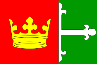
Flag Description: The flag consists of two vertical stripes, red with a yellow crown and green, in a width ratio of 3:2. Adjacent to the red stripe in the green field is the half of a white florety cross (cross fleury), with the tips of its arms reaching the upper, lower, and fly edges of the sheet. The aspect ratio of the flag is 2:3.
Symbolism: The golden crown and red field refer to Emperor Joseph II, under whose initiative the settlement was founded in 1785, making it a canting emblem reflecting the name Císařov (historically Kaiserwerth). The half white lilied cross in the green field commemorates the dissolved Dominican convent of St. Catherine in Olomouc, on whose former estates the village was established, while the green tincture symbolizes the agricultural character and fertile landscape of the Haná region.
Statistics
Area
2.99 km²
Population
319