Colinas do Sul
Digital Passport
Nomenclature and Geography
Category: City / Municipality
Summary
About the place: Colinas do Sul is a municipality located in the north-central region of the state of Goiás, Brazil, near the Chapada dos Veadeiros National Park. It is known for its scenic hilly landscape, rivers, and ecotourism opportunities.
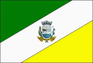
Flag Description: The flag is divided diagonally from the bottom-hoist corner to the top-fly corner into three sections. The upper triangle is green, the broad central diagonal stripe is white, and the lower triangle is yellow. Positioned in the center of the white stripe is the municipal coat of arms featuring a mural crown, a shield divided into multiple fields, and a golden scroll below inscribed with the name 'COLINAS DO SUL' and the date '01-06 1989'.
Symbolism: The green color symbolizes the rich vegetation, forests, and agriculture of the region. White represents peace and purity. Yellow represents mineral wealth and sunshine. The municipal coat of arms in the center depicts local history, cattle farming, water resources, and the official date of municipality establishment.
Statistics
Area
1,708.20 km²
Population
3,358