Coronel Sapucaia
Digital Passport
Nomenclature and Geography
Category: City / Municipality
Summary
About the place: Coronel Sapucaia is a municipality located in the south of the state of Mato Grosso do Sul, Brazil, directly on the border with Paraguay. It borders the Paraguayan city of Capitán Bado, forming a conjoined binational urban area.
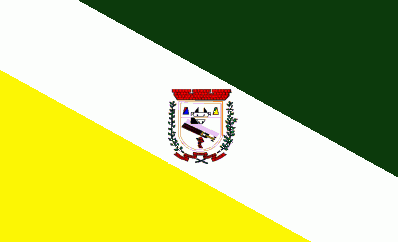
Flag Description: The flag is divided diagonally into three fields. The upper field (from the top hoist to the upper fly) is dark green, while the lower field (from the bottom hoist to the lower fly) is yellow. A broad diagonal white bend runs across the center, bearing the municipal coat of arms in its middle. The emblem features a shield topped with a red mural crown, flanked by green branches and a red ribbon below, containing various internal symbols.
Symbolism: The green color symbolizes the region's rich nature, forests, and agriculture. Yellow represents wealth, sunshine, and crop production, while white signifies peace. The municipal coat of arms in the center highlights the history, autonomy, and local identity of Coronel Sapucaia.
Statistics
Area
1,028.90 km²
Population
14,160