Cristianópolis
Digital Passport
Nomenclature and Geography
Category: City / Municipality
Summary
About the place: Cristianópolis is a Brazilian municipality located in the southeastern region of the state of Goiás. The town has a predominantly agricultural character and is known for its peaceful rural atmosphere.
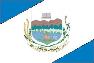
Flag Description: The flag consists of a broad white diagonal band extending from the top hoist and top center towards the lower fly, with the upper hoist-side triangle and lower fly-side triangle colored blue. In the center of the flag rests the municipal coat of arms. The shield depicts a landscape featuring mountains, vegetation, a river, an animal, and an open book at the top, flanked by agricultural crops and a scroll below reading '23-6 CRISTIANÓPOLIS 1953'.
Symbolism: The blue and white colors represent peace, the sky, and the water resources of the region. The central coat of arms illustrates the local natural environment, the importance of agriculture (shown by the crops flanking the shield), and education or faith symbolized by the open book. The date on the ribbon marks the establishment or autonomy of the municipality.
Statistics
Area
495.40 km²
Population
3,000