Dasný
Digital Passport
Nomenclature and Geography
Category: City / Municipality
Summary
About the place: Dasný is a South Bohemian municipality and village situated in the České Budějovice Basin, approximately 6 km northwest of České Budějovice. The surrounding flat terrain is defined by agricultural land and numerous wetlands, directly bordering the Vrbenské ponds nature reserve.
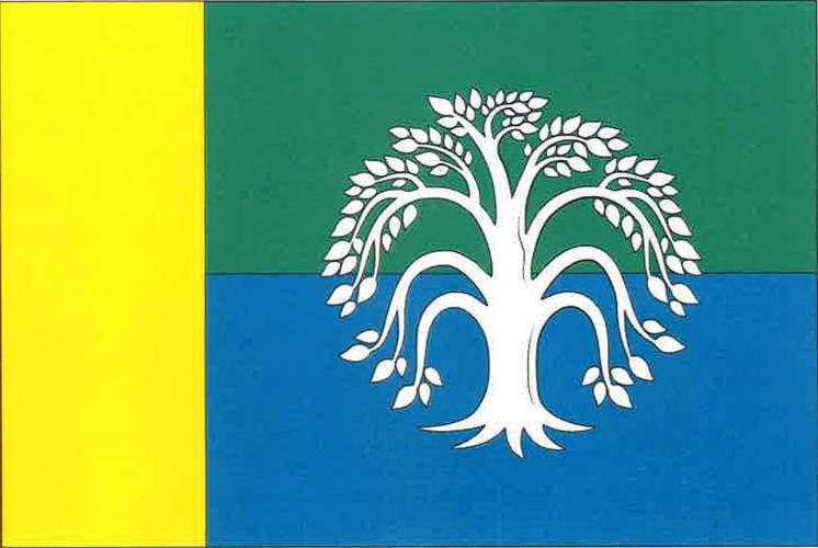
Flag Description: The flag consists of a yellow hoist stripe occupying one-fourth of the flag's length, and two horizontal stripes, green over blue, charged with a white eradicated willow tree centered across both stripes. The aspect ratio is 2:3.
Symbolism: The white eradicated willow tree, along with the green and blue stripes, symbolizes the surrounding natural landscape rich in meadows, wetlands, and fishponds (including the neighboring Vrbenské ponds). The yellow hoist stripe represents the royal crown from the municipal coat of arms, commemorating the village's historic establishment on royal domain (reflected in the historic German name Kronfellern).
Flag Description: The flag consists of a yellow hoist stripe occupying one-fourth of the flag's length, and two horizontal stripes, green over blue, charged with a white eradicated willow tree centered across both stripes. The aspect ratio is 2:3.
Symbolism: The white eradicated willow tree, along with the green and blue stripes, symbolizes the surrounding natural landscape rich in meadows, wetlands, and fishponds (including the neighboring Vrbenské ponds). The yellow hoist stripe represents the royal crown from the municipal coat of arms, commemorating the village's historic establishment on royal domain (reflected in the historic German name Kronfellern).
Statistics
Area
3.40 km²
Population
353