Dolní Němčí
Digital Passport
Nomenclature and Geography
Category: City / Municipality
Summary
About the place: Dolní Němčí is a municipality and village in Uherské Hradiště District in the Zlín Region of the Czech Republic, situated in the foothills of the White Carpathians within the ethnographic region of Moravian Slovakia (Slovácko). Located along the Okluka stream, it is renowned for its vibrant folklore heritage, agriculture, and viticulture.
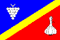
Flag Description: Dolní Němčí is a municipality and village in Uherské Hradiště District in the Zlín Region of the Czech Republic, situated in the foothills of the White Carpathians within the ethnographic region of Moravian Slovakia (Slovácko). Located along the Okluka stream, it is renowned for its vibrant folklore heritage, agriculture, and viticulture.
Symbolism: The symbols on the flag derive from the municipal coat of arms and local history. The grape bunch represents traditional viticulture in the Moravian Slovakia wine region, while the bulb of garlic symbolizes the municipality's renowned historic specialty of garlic cultivation, which made Dolní Němčí a major national garlic-producing center in the 20th century. The yellow diagonal stripe and the blue and red fields reflect the heraldic tinctures of the coat of arms (a golden rake on a blue-red divided field).
Statistics
Area
9.88 km²
Population
2,866