Dourados
Digital Passport
Nomenclature and Geography
Category: City / Municipality
Summary
About the place: Dourados is the second most populous municipality in the Brazilian state of Mato Grosso do Sul and a major economic and educational hub. Located in the southern part of the state, it is renowned for its strong agricultural sector.
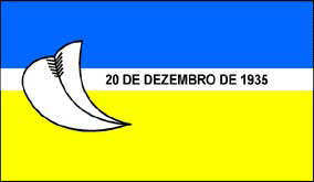
Flag Description: The flag consists of three horizontal bands: blue, a narrow white stripe in the middle, and yellow. On the left side from the viewer's perspective, spanning across all three bands, is a large white stylized sail or feather-like emblem outlined in black with internal ribbing. To the right of this emblem, within the central white stripe, is the black text '20 DE DEZEMBRO DE 1935'.
Symbolism: The blue color symbolizes the sky and clear waters, while the yellow represents the region's agricultural wealth and prosperity. The white stripe signifies peace and purity. The stylized white emblem, resembling a plow or quill, symbolizes labor and cultural development. The date '20 DE DEZEMBRO DE 1935' marks the official date of municipality establishment (emancipation) of Dourados.
Statistics
Area
4,086.40 km²
Population
243,367