Guaíra, Paraná
Digital Passport
Nomenclature and Geography
Category: City / Municipality
Summary
About the place: Guaíra is a municipality located in the state of Paraná, Brazil, situated on the western border along the Paraná River near Paraguay. It is historically known for its location near the former Guaíra Falls and its role as an important river transit point.
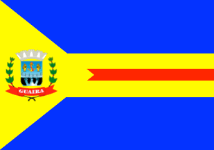
Flag Description: The flag consists of a blue field with a yellow triangle extending from the hoist edge to the center. From the apex of the triangle, a horizontal yellow band extends toward the fly, containing a narrower red stripe with a swallowtail finish pointing toward the hoist. Inside the yellow triangle near the hoist is the coat of arms of Guaíra, featuring a blue shield with a silver bridge, fish, anchor, and waterfalls, surmounted by a silver mural crown and flanked by green branches joined by a red ribbon inscribed 'GUAÍRA' in white.
Symbolism: The blue color symbolizes the sky and the water resources of the Paraná River. Yellow represents wealth and the agricultural production of the region. The red stripe signifies the courage and labor of the pioneers, while the anchor and bridge elements in the emblem highlight navigation, border connection, and the historical waterfalls.
Statistics
Area
560.81 km²
Population
33,320