Horní Blatná
Digital Passport
Nomenclature and Geography
Category: City / Municipality
Summary
About the place: Horní Blatná (German: Bergstadt Platten) is a historic mountain town in the Karlovy Vary District of the Czech Republic, situated on the ridges of the Ore Mountains at an elevation of around 890 metres above sea level. Founded in the 16th century as a planned Renaissance tin-mining town, its well-preserved urban core is designated as an urban heritage zone and forms part of the UNESCO World Heritage Site Ore Mountain Mining Region.
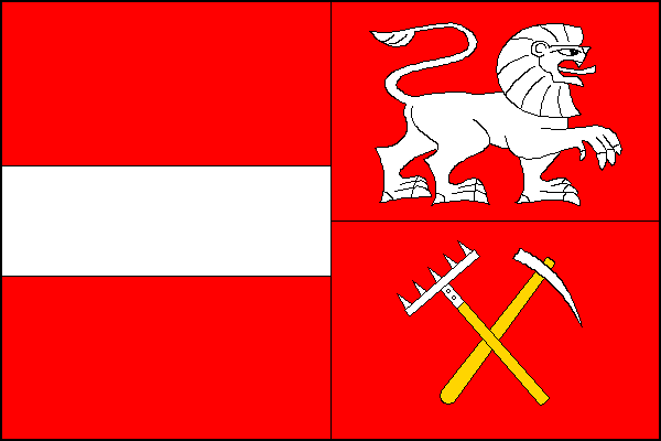
Flag Description: A flag with an aspect ratio of 2:3, vertically divided into two equal halves. The hoist half is divided horizontally into three stripes of red, white, and red in proportions of 3:2:3. The fly half is red, featuring a white lion passant contourné (facing toward the fly) above a white tin-washing rake set bendwise, underlaid by a white miner's pickaxe set bendwise sinister; both tools have yellow hafts.
Symbolism: The flag is derived from the historic municipal coat of arms granted to the town in 1555 by King Ferdinand I of Habsburg. The red-white-red horizontal stripes in the hoist half represent the silver fess on red from the dexter half of the town's shield, reflecting Bohemian colours and royal grant. The white lion contourné and the crossed tools below—a tin-washing rake and a miner's pickaxe—symbolise the town's 16th-century establishment specifically for mining and washing rich alluvial and vein tin ores.
Statistics
Area
5.63 km²
Population
365