Horní Olešnice
Digital Passport
Nomenclature and Geography
Category: City / Municipality
Summary
About the place: Horní Olešnice is a rural municipality situated in the valley of the Kalenský Stream at the foothills of the Krkonoše Mountains, located in the Trutnov District within the Hradec Králové Region. It is known for its well-preserved timbered folk architecture and regional deposits of semi-precious stones and Bohemian garnets.
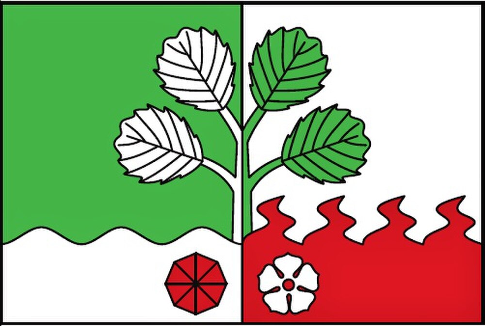
Flag Description: The flag consists of two vertical stripes of green and white, with a lower horizontal stripe occupying one-fourth of the flag's width that is wavy and white below the green stripe, and red with four flames below the white stripe. Arising along the vertical dividing line between the green and white stripes is an alder branch with four leaves of counterchanged colours. Below it, in the white field, is a red faceted Bohemian garnet, and in the red field, a white rose with a red seed centre. The ratio of width to length is 2:3.
Symbolism: The alder branch is a canting charge referring to the municipality's name (derived from alder trees along the stream), with its four leaves representing the four historical parts and cadastres of the municipality (Horní Olešnice, Prostřední Olešnice, Přední Ždírnice, and Zadní Ždírnice). The white wavy stripe symbolizes the Kalenský Stream flowing through the valley. The red flaming stripe with four flames alludes to historical village seals and the etymology of Ždírnice (derived from slash-and-burn woodland clearing). The faceted red Bohemian garnet represents the famous regional deposits of pyropes and semi-precious stones in the village's territory, while the white rose is derived from historical local seals and the heraldry of past feudal nobility.
Flag Description: The flag consists of two vertical stripes of green and white, with a lower horizontal stripe occupying one-fourth of the flag's width that is wavy and white below the green stripe, and red with four flames below the white stripe. Arising along the vertical dividing line between the green and white stripes is an alder branch with four leaves of counterchanged colours. Below it, in the white field, is a red faceted Bohemian garnet, and in the red field, a white rose with a red seed centre. The ratio of width to length is 2:3.
Symbolism: The alder branch is a canting charge referring to the municipality's name (derived from alder trees along the stream), with its four leaves representing the four historical parts and cadastres of the municipality (Horní Olešnice, Prostřední Olešnice, Přední Ždírnice, and Zadní Ždírnice). The white wavy stripe symbolizes the Kalenský Stream flowing through the valley. The red flaming stripe with four flames alludes to historical village seals and the etymology of Ždírnice (derived from slash-and-burn woodland clearing). The faceted red Bohemian garnet represents the famous regional deposits of pyropes and semi-precious stones in the village's territory, while the white rose is derived from historical local seals and the heraldry of past feudal nobility.
Statistics
Area
12.73 km²
Population
304