Horní Těšice
Digital Passport
Nomenclature and Geography
Category: City / Municipality
Summary
About the place: Horní Těšice is a small rural municipality situated in the southeastern part of Přerov District in the Olomouc Region, approximately 9 km south of Hranice in the rolling landscape of the Sub-Beskidian Foothills. The first written mention of the settlement dates back to 1131 in a charter of Olomouc Bishop Jindřich Zdík.
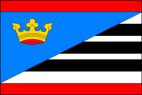
Flag Description: The flag consists of nine horizontal stripes – red, white, black, white, black, white, black, white, and red in a width ratio of 2:2:2:1:2:1:2:2:2. The white and black stripes are overlaid by a blue hoist triangle with its apex at the center of the field, bearing a yellow crown in its hoist half. The flag's width-to-length ratio is 2:3.
Symbolism: The municipal symbols granted in 2001 reflect the local history: the red color commemorates the historical ties to the Bishopric of Olomouc, which held the territory in the early Middle Ages (heraldically represented by silver cones in a red shield chief). The black bars on a white/silver field recall the coats of arms of local historical feudal lords, while the blue field and golden crown symbolize sovereign authority, dignity, and local heritage.
Statistics
Area
3.22 km²
Population
150