Hrabůvka
Digital Passport
Nomenclature and Geography
Category: City / Municipality
Summary
About the place: Hrabůvka is a municipality in the Olomouc Region (Přerov District) of the Czech Republic, situated on the border between the Moravian Gate and the Oder Highlands near Hranice. It is a quiet rural village nestled among forested hills, historically linked to agriculture and greywacke quarrying.
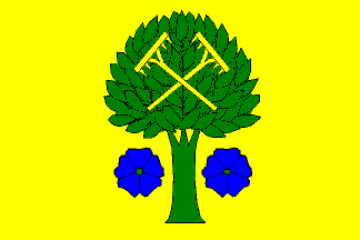
Flag Description: A yellow field with a green couped hornbeam tree bearing two crossed yellow rakes in its crown, flanked at the trunk by two blue flax blossoms with green centres. The ratio of the width to the length of the sheet is 2:3.
Symbolism: The symbolism represents a double canting (punning) motif. The rakes derive from the village's historic 1766 seal and a folk etymology of the name (from 'hrábě' – rakes), while the hornbeam tree (dialectally 'hrab') refers to the linguistic origin of the name Hrabůvka as well as the native hornbeam-oak forests. The blue flax blossoms symbolize the centuries-old tradition of flax cultivation in the region.
Statistics
Area
3.06 km²
Population
338