Hutisko-Solanec
Digital Passport
Nomenclature and Geography
Category: City / Municipality
Summary
About the place: Hutisko-Solanec is a municipality in the Vsetín District of the Zlín Region, located in the valley of the Rožnovská Bečva River and along the slopes of the Vsetín Hills below Mount Soláň. It was formed in 1960 by merging two historic Wallachian villages, Hutisko and Solanec pod Soláněm.
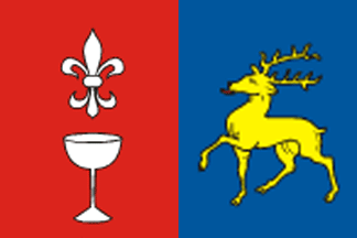
Flag Description: The flag is vertically divided into a red hoist part with a white fleur-de-lis above a white glass goblet, and a blue fly part with a yellow walking stag with a red tongue facing the hoist. The ratio of the width to the length of the flag is 2:3.
Symbolism: The glass goblet commemorates the 17th-century glassworks from which the village of Hutisko took its name. The fleur-de-lis represents church tradition and purity (patronage of St. Joseph). The walking stag symbolizes the abundant Beskid nature, deep forests, and mountain wildlife of the Vsetín Hills and Mount Soláň. The vertical division into red and blue fields reflects traditional regional colors and represents the union of the two historical settlements.
Statistics
Area
29.91 km²
Population
1,974