Iracema, Roraima
Digital Passport
Nomenclature and Geography
Category: City / Municipality
Summary
About the place: Iracema is a municipality located in the central-western part of the state of Roraima, Brazil.
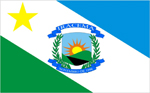
Flag Description: The flag is divided diagonally into three fields: a light blue triangle in the upper right (viewer's perspective), a green triangle in the lower left, and a broad white diagonal band extending from the upper left to the lower right. A yellow five-pointed star is located in the upper left corner of the white band. In the center of the flag is the municipal coat of arms featuring a landscape with a rising sun, green hills, and a river, framed by green branches and blue ribbons inscribed with 'IRACEMA' at the top and the date '04 DE DEZEMBRO DE 1990' at the bottom.
Symbolism: Light blue represents the sky and the region's water resources, green symbolizes the lush vegetation and forest, and white stands for peace. The yellow star refers to the state of Roraima and the bright future of the municipality. The municipal shield depicts the local landscape, a river, a sun symbolizing hope, and branches representing agricultural wealth, alongside the date of the municipality's creation.
Statistics
Area
4,884.20 km²
Population
10,023