Mundo Novo, Mato Grosso do Sul
Digital Passport
Nomenclature and Geography
Category: City / Municipality
Summary
About the place: Mundo Novo is the southernmost municipality in the Brazilian state of Mato Grosso do Sul, located right on the border with both Paraná state and neighboring Paraguay. The town has strong agricultural roots and serves as an important border hub in the region.
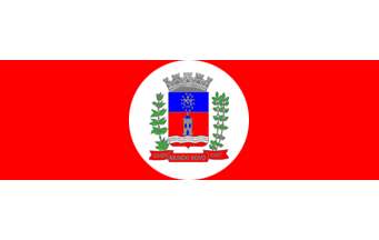
Flag Description: The flag consists of three horizontal bands: white, red, and white. The central red band is wider than the outer white bands. In the center of the flag lies a white circular disc bearing the municipal coat of arms. The shield of the coat of arms is divided horizontally into a blue upper half with a monogram encircled by stars and a red lower half featuring a tower above wavy lines. The shield is crowned with a silver mural crown, flanked by green plant branches, and rests above a red scroll with the white inscription 'MUNDO NOVO' and dates.
Symbolism: The red and white colors symbolize courage, peace, and purity of intention. The municipal coat of arms in the central white disc represents municipal autonomy; the tower signifies defense and fortitude, the wavy lines represent local rivers, and the green branches recall the region's agricultural wealth and production.
Statistics
Area
479.30 km²
Population
19,193