Neuenhaus
Digital Passport
Nomenclature and Geography
Category: City / Municipality
Summary
About the place: Neuenhaus is a town in the Grafschaft Bentheim district in Lower Saxony, Germany, located close to the Dutch border. Situated along the Vechte River, it serves as the administrative seat of the Samtgemeinde Neuenhaus.
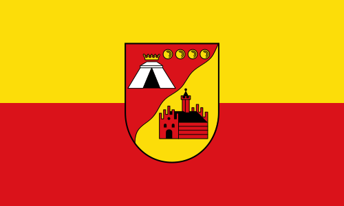
Flag Description: The flag consists of a horizontal bicolour of two equal bands of yellow on top and red at the bottom. In the center of the flag is the town's coat of arms. The shield is divided diagonally by a wavy line into red and yellow. In the upper red field, there is a silver tent surmounted by a crown, with four golden spheres arranged diagonally along the upper edge. In the lower yellow field, a red castle with a tower is depicted.
Symbolism: The colors yellow and red derive from the traditional heraldic colors of the County of Bentheim. The coat of arms in the center symbolizes the town's history: the wavy diagonal line represents the Vechte River, the red castle building signifies the new castle ('Neues Haus') from which the town derived its name, and the figures in the upper section recall historical noble connections and local landmarks.
Statistics
Area
31.33 km²
Population
10,561